The Gan-Yue Ancient Road and Meiguan Pass
Geographic Connections
Standing at the Zhemei Pavilion on the Dayuling ridge and looking south, you can see the Gujiaowei confluence (modern Ganzhou’s Zhanggong District) where two rivers part ways. The Zhang River flows north toward Poyang Lake and the Yangtze; the Gong River flows south into the Pearl River system. One ridge, two rivers, two directions. Meiguan Pass sits at the lowest saddle of this ridge, only 430 meters above sea level—the easiest breach across the entire Nanling Mountains. From the Qin and Han dynasties through Ming and Qing, any army or merchant caravan traveling between Lingnan and the north had to pass through this saddle.
I. The Qin’s 500,000 Troops: The First Breach of Dayuling
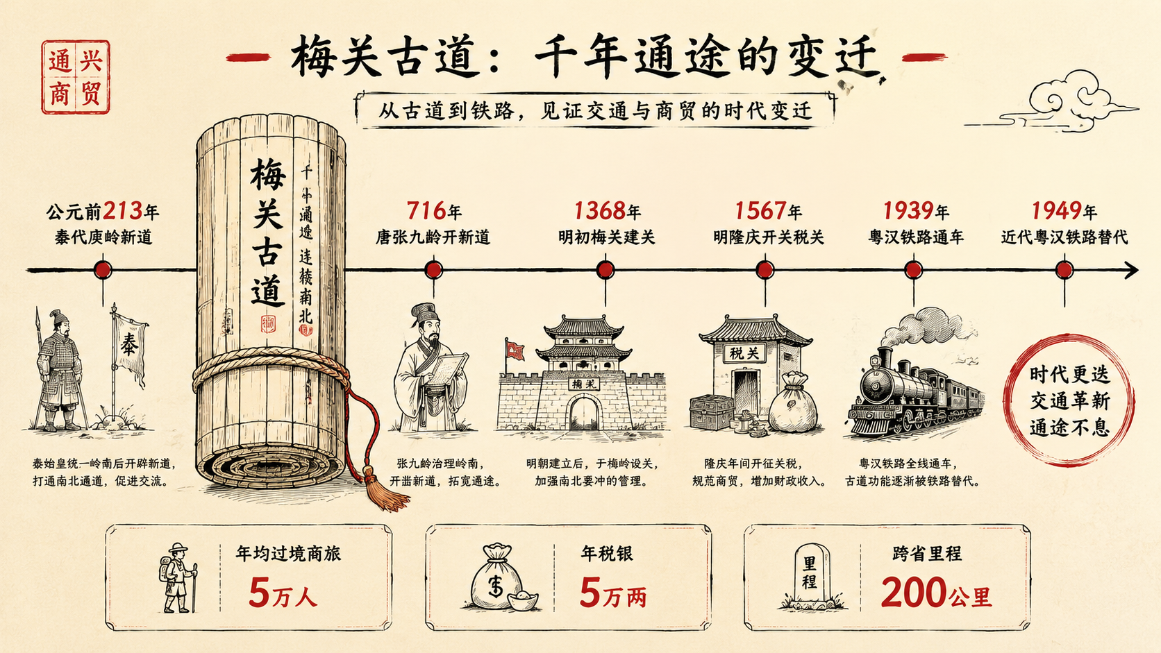
In 221 BCE, one year after unifying the Central Plains, Qin Shi Huang dispatched an army of 500,000 to conquer the Hundred Yue tribes. The greatest obstacle on this expedition was the Nanling range—and Dayuling (the Greater Yuling) was the hardest to cross. Qin’s engineers tackled the ridge in a near-brutal way, hacking out the first barely-walkable trail along the crest. This was historically called the “Tongnanyue Road” (Road to Southern Yue).
In 212 BCE this road was officially opened. At almost the same moment, the Qin established Hengpu Pass in the northern foothills of Dayuling—this was the predecessor of later Meiguan Pass. It was the first time in history that human tools had forcibly broken through this natural barrier of the Nanling.
But the more telling chapter came in 112 BCE during the Western Han. That year, the Nanyue Kingdom’s Lü Jia rebelled. Emperor Wu sent General Yang Pu with a massive naval-army force through Meiguan again to quell the rebellion. After the war, two garrison commanders named Yu Sheng were ordered to stay and defend the area, building a fortress north of the ridge. “Dayuling” (Greater Yuling) was named after Yu Sheng—and from then on, this military road evolved into a strategic north-south corridor over two centuries of Qin-Han consolidation.
Notably, two-thirds of the empire’s major grain depots outside the southern dynastic capitals were located in Jiangxi at this time—all of them relying on this water-and-land transit corridor. Jiangxi’s “granary of China” status, from the very beginning, was tied to Meiguan Pass.
II. Zhang Jiuling’s Homecoming: 25 Li of Flagstones in 716 CE
After the Tang Dynasty, the national economic center gradually shifted southward. The old Meiguan footpath was no longer adequate—“carriages couldn’t fit on it, goods had to be carried on backs.” Travelers had no choice but to haul everything themselves.
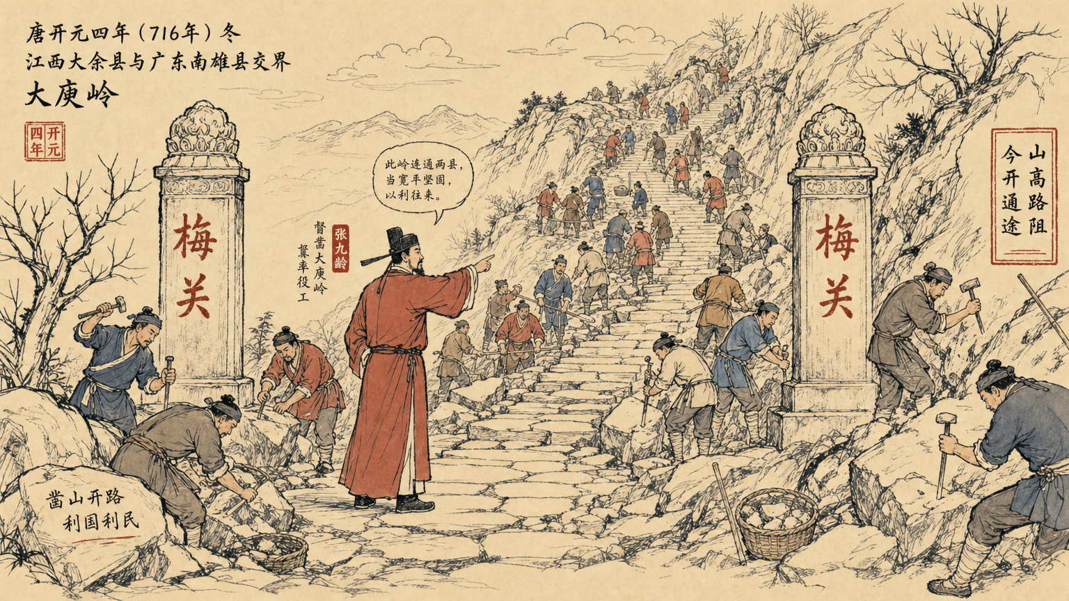
The turning point came in 716 CE, the fourth year of Kaiyuan. That year, the famous Prime Minister Zhang Jiuling resigned his post to return home—his hometown was Qujiang in Guangdong, and the journey from Chang’an to Lingnan required crossing Dayuling. When he personally experienced this treacherous path, this poet who would later be honored as the “First Person of Lingnan” made a decision: rather than curse the darkness, carve through the mountain.
He petitioned Emperor Xuanzong for permission to rebuild the road. After receiving imperial approval, during the farming off-season, he personally surveyed and designed the route, supervising workers “along the ledges, through the thickets,” breaking ground at Dayuling’s highest point. This construction was far more refined than the Qin-Han version—the finished road was about 1 zhang wide (roughly 3.3 meters), stretched 25 li (about 12.5 kilometers), paved with neat flagstones throughout, and graded to a slope where horses and humans could pass comfortably.
After completion, the Kaiyuan Record described the scene: “so flat five carriages could run abreast, so bustling traffic flowed in all four directions.” This was the first time in Chinese history that a south-north corridor had been built to genuine engineering standards.
The effect was stunning. In 793 CE (Zhengyuan ninth year), national tea tax revenue reached 400,000 guan, much of which traveled through Dayuling for export to Lingnan. After the An Lushan Rebellion, Jiangnan silk, porcelain, and tea bound for Guangzhou’s overseas trade routes had to traverse this road. Meiguan transformed from a military supply line into the land bridge of the Tang Empire’s “Maritime Silk Road.”
III. Building Meiguan Pass: From Post Road to “First Pass of Lingnan”
In 1063 CE (Jiayou eighth year), Cai Ting, the Nan’an Military Commissioner, built a brick-and-stone pass fortress at Dayuling’s 430-meter-elevation saddle. The south face bore the inscription “First Pass of Lingnan” (岭南第一关); the north face read “Mighty Pass of Southern Yue” (南粤雄关)—these eight characters marked that Meiguan had ceased being a mere post station and was now the formal administrative boundary between Jiangxi and Guangdong.
In 1479 CE (Chenghua fifteenth year), Zhang Bi, the Nan’an Prefect, undertook a critical renovation. The ridge road had fallen into disrepair—“after days of rain, it nearly became a ditch.” Zhang Bi carved stone from the mountain and filled gaps, completing the work in 1 year and 2 months. He also instituted a far-reaching convention—Nan’an and Nanxiong porters would “exchange” cargo at the summit: Jiangxi porters would set their loads down at the peak and return; Guangdong porters would receive them and continue south. This settled a 20-plus-year dispute over transit profits.
In 1511 CE (Zhengde sixth year), the Gan Pass was formally established in southern Jiangxi, initially at Zhemei Pavilion on the Meiguan post road, later moved to Gujiaowei in Ganzhou. By the Wanli era, annual commercial tax revenue reached 45,000 taels of silver. Meiguan was no longer just a corridor—it was a major revenue checkpoint of the Ming state.
IV. Guangdong Salt, Jiangxi Grain: A Thousand Years of Population and Salt Movement
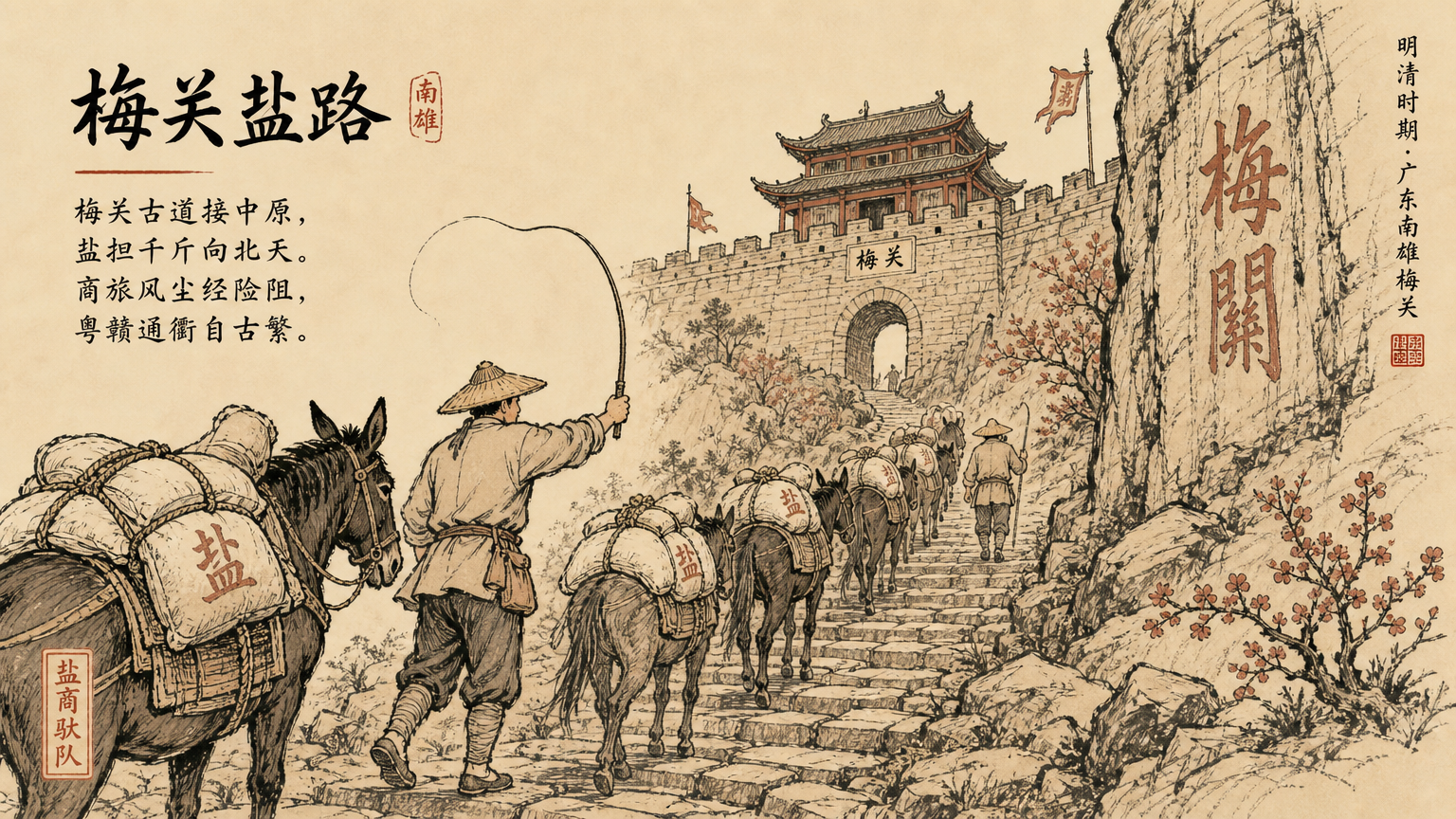
The Ming and Qing dynasties saw the peak commercial era of the Gan-Yue Ancient Road.
First, Guangdong salt flowing north. Jiangxi has no salt. The salt supply for southern and central Jiangxi residents came entirely from “Guangyan” (Guangdong salt) flowing north. The route: Guangzhou, up the Bei River to Nanxiong, over Meiguan Pass to Dayu, then by waterway to all parts of southern Jiangxi. In 1791 CE (Qianlong fifty-sixth year), the salt certificate trade volume monitored by the Jiujiang and Gan Pass customs was staggering—annual Guangdong salt transport in mid-Qing reached tens of millions of catties. The transport tools were carrying poles, baskets, and single-wheel carts—purely human-powered, every cattie carried across Meiguan on someone’s shoulder.
Then Jiangxi grain flowing south. As the “Southeast’s Financial Granary,” Jiangxi’s grain exports via Meiguan were equally massive. During the Ming and Qing dynasties, Jiangxi annually exported about 2 million shi (roughly 140 million liters) of rice to Jiangsu and Zhejiang, part of which went up the Gan River to Dayu, crossed the ridge into Guangdong. Beyond grain, Jiangxi’s Jingdezhen porcelain, Wuyuan Hechuan black tea, and Wanzai firecrackers were also regular travelers on this ancient road. In 1610 CE (Wanli thirty-eighth year), of the 9,227 pieces of porcelain China exported to the Netherlands, the vast majority traveled through this overland transit system to Guangzhou for export.
A million catties of salt in, two million shi of grain out—this was Meiguan’s real annual throughput. If you drew this ancient road as a line on a map, its flow rate would rival certain sections of the contemporary Grand Canal.
V. Chen Yi’s Three Poems and the Nan-Xiao Highway
The Gan-Yue Ancient Road was not only a wealth corridor but a cultural melting pot. The Southern Dynasties poet Lu Kai wrote here the famous line: “Plucking plum blossoms to meet a courier, I send them to one across the ridge.” The Tang poet Liu Changqing also lamented: “Crossing Meiguan again, year after year the northern branch is cold.” These verses, surviving a millennium, remain today the iconic images of Lingnan cultural imagination.
After the 1840 Opium War, with the opening of Shanghai as a treaty port, Dayuling post road’s status began to shake. In 1858 (Xianfeng eighth year), the Sino-British Treaty of Tianjin opened Jiujiang as a treaty port—massive import-export cargo shifted to the Yangtze shipping channel, and the ancient road gradually faded.
In 1934 (Republic of China twenty-third year), the Nan-Xiao Highway (Nanchang to Xiaomeiguan) was fully completed, about 525 kilometers long. Modern automobile transport gradually replaced traditional human porterage and horse caravans.
And yet Meiguan’s cultural symbol still stands tall. During the Second Revolutionary Civil War period, Meiguan became an important stronghold for Red Army guerrilla warfare. The three “Meiguan Poems” written by Chen Yi here infused this ancient pass with a new heroic spirit—
How does the severed head feel today? Founding was hard, fought a hundred battles. From here to the springs below I summon my old troops, banners ten thousand slashing Yama.
Today, Meiguan’s preserved ancient road stretches about 25 li, not only a national key cultural relic protection unit, but a living fossil witnessing a thousand years of Central Plains and Lingnan integration. From the Qin army first breaking through Dayuling in 212 BCE, to the 1934 Nan-Xiao Highway opening, to today’s Beijing-Hong Kong high-speed rail tunnel piercing beneath Meiguan’s feet—two thousand two hundred years of north-south corridor history, condensed into this stone-built pass at 430 meters elevation.