In the 16th-century global trade network, the Jiulong River was the “capillary” connecting the Ming Empire to global silver flows.
After analyzing 16 historical sources including the Wanli Zhangzhou Prefecture Chronicle and Zhangzhou Agricultural Reclamation Chronicle, I discovered that Zhangzhou’s water system was not merely a natural river network—it was a sophisticated “hydraulic machine” composed of natural channels, artificial dikes, and monolithic stone bridges.
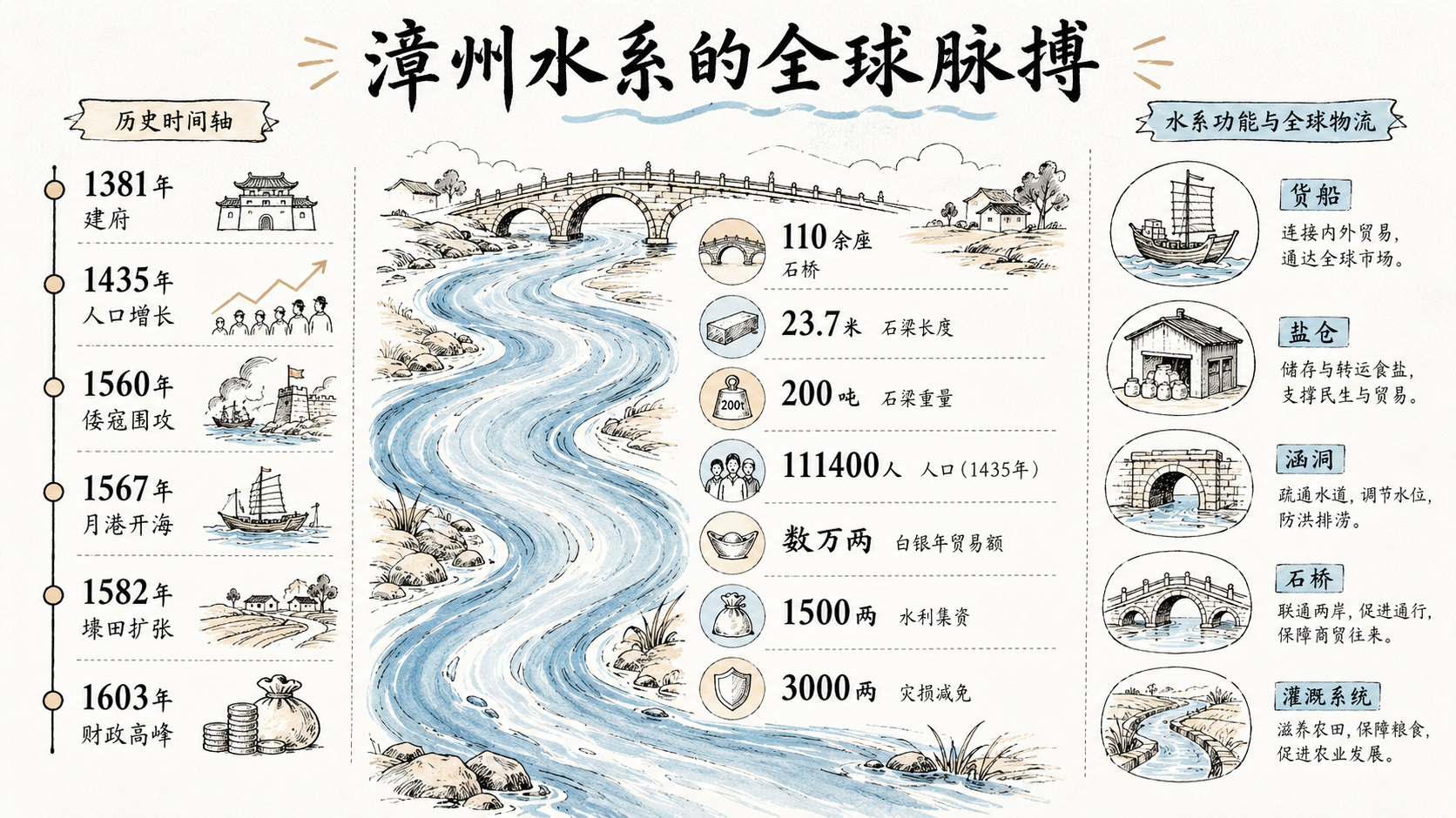
From the original waterways of 1381 to the crisscrossing dike-fields and stone bridges of the late Wanli era, this system transformed from a “natural landscape” into a “global logistics platform.”
Jiulong River (North/West Stream), Zhangzhou City, Moon Harbor (Yuegang), Jiangdong Bridge (Longjiang Bridge), Haicheng, Longxi, Zhangpu, Nanjing, Pinghe, Changtai, Jiulong River Estuary
Urban Space Embraced by Dual Rivers
The North and West streams of the Jiulong River converged southeast of Zhangzhou city, a feature depicted as “Reclining Dragons over Waves” in the 1573 prefecture maps.
This confluence was strategically vital. During the massive Wokou siege of 1560, Zhangzhou maintained essential supplies through its waterways.
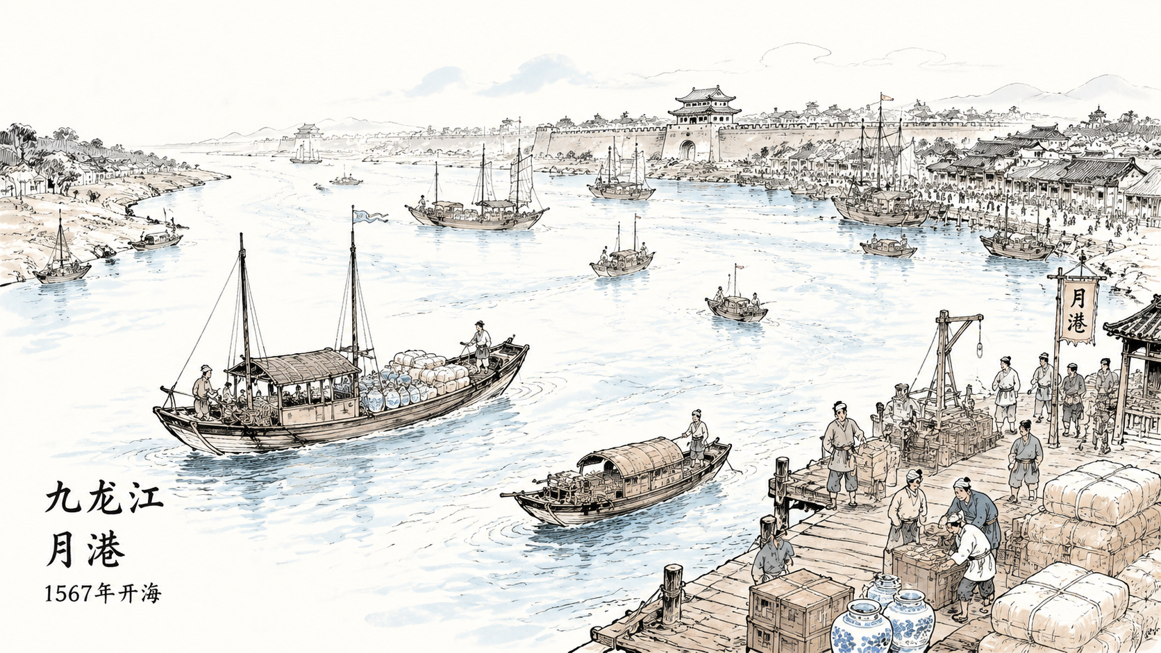
By 1435, Zhangzhou’s population surged to over 111,400. After Moon Harbor opened for trade in 1567, hundreds of wooden boats plied the Jiulong River daily. Estimates suggest the annual value of goods and silver transported reached tens of thousands of liang—the river became an “invisible conveyor belt” connecting the Ming Empire to global markets.
Shipping Network: From Hinterland to Moon Harbor Hub
Shipping in Zhangzhou followed strict commercial and fiscal logic.
During the Longqing-Wanli period (1567-1620), a radial shipping network centered on Moon Harbor emerged. Raw silk and porcelain flowed down the North Stream to be distributed at Yuegang in Haicheng. Fiscal audits from 1603 showed Zhangzhou’s commercial tax revenue accounted for a significant portion of provincial totals.
Waterways also served as channels for state-monopolized resources. From its establishment in 1381, Zhangzhou’s salt taxation was closely integrated with waterway layout. By 1587, every vessel’s tonnage and cargo required registration at designated ports—a digitalized control system ensuring the state’s reach into economic “capillaries.”
Man-Made Geography: Dikes and Hydraulic Engineering
Another defining feature was the massive artificial reclamation network.
During the Hongzhi-Zhengde period (1488-1521), the “Dike-Field” (Daitian) model was widely adopted—building long embankments to block saltwater. Records show constructing a standard 500-zhang sea dike required precise labor mobilization through the Lijia system. This transformation of water boundaries converted barren tidal flats into taxable farmland after 1582.
For irrigation stability, the system featured numerous micro-irrigation nodes. The 1603 land survey recorded thousands of qing of land equipped with advanced sluice and drainage systems. A 1590 repair project raised over 1,500 liang of silver locally—demonstrating significant capital investment in hydraulic infrastructure.
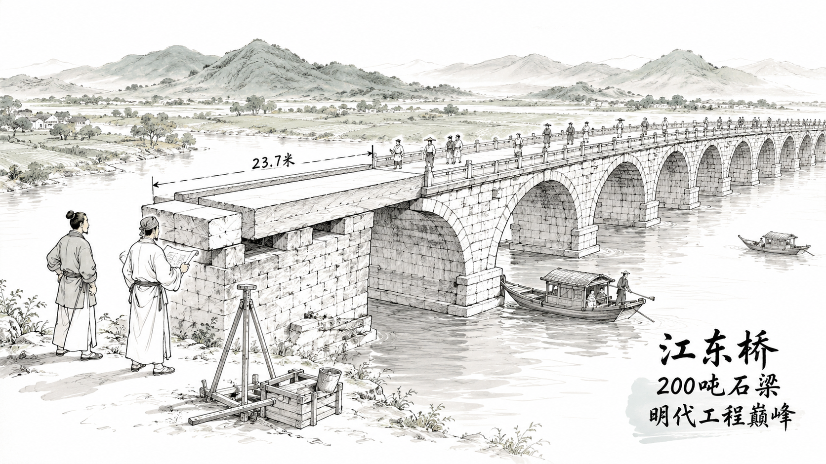
Monolithic Structures: Jiangdong Bridge’s Engineering Pinnacle
Bridges were engineered responses to river dynamics.
Jiangdong Bridge (Longjiang Bridge) spanning the North Stream was a landmark. Its surviving stone beams reach 23.7 meters long and weigh over 200 tons. 1613 repair records document how craftsmen used tidal buoyancy to install these massive beams—a pinnacle of Ming engineering.
By 1573, official records counted over 110 stone bridges in Zhangzhou prefecture. Concentrated along logistics axes to Moon Harbor, Longxi County achieved 0.8 bridges per ten square kilometers—a leading density in the empire’s southeastern coast.
Disaster and Social Resilience
Water systems brought both prosperity and peril.
In 1586, a combined plague and flood caused massive population loss. In March 1591, a major earthquake cracked the earth and disrupted irrigation systems with “black water surging forth.”
The Ming court developed standardized disaster response mechanisms. The 1606 audit recorded over 3,000 liang in tax remissions for counties affected by the 1604 earthquake’s saltwater intrusion. This dynamic, data-driven management reflected precise administrative response to hydrological complexity.
Conclusion
From the natural waterways of 1381 to the interconnected dike-fields and stone bridges of late Wanli, Zhangzhou’s water system underwent a remarkable transformation.
Every river reach and sluice gate pulsed with the rhythm of the silver trade. In the digital humanities context, Zhangzhou’s water system is not merely geographic coordinates—it is a grand database of survival, technology, and globalization interactions.
Every current in the Jiulong River carried the pulse of 16th-century globalization.